Home
HILLSBOROUGH COMMUNITY COLLEGE DIGITAL LIBRARY
User account menu
  • Log in

Breadcrumb

  1. Home
  2. Root
  3. HCC Digital Collections
  4. Community Collections
  5. Southern Hillsborough County History
  6. Southern Hillsborough County - General Collections
  7. South County - Early Land Survey Records

Township 30S Survey Maps: Ranges 19E to 22E

Description
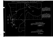
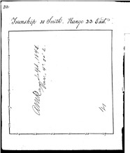
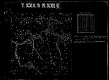
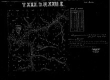
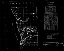
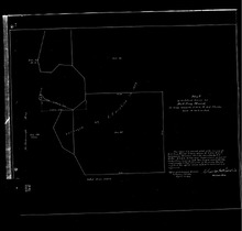
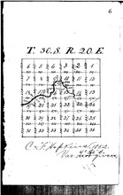
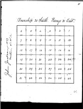
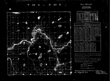
This collection of survey maps, most from 1843-1848, are the initial survey maps by the Territory and State of Florida to enable land sales. This town ship encompasses land within the Alafia River basin, Gibsonton, Riverview (North), Progress Village, Bloomingdale, Lithia and Pinecest, then east to the Polk County line.
Language
eng
Displaying 1 - 11 of 11

1930 Survey Map of 2 Islands at the Mouth of the Alafia River

hccfl_1692-Thumbnail Image.jpg
Type: Still Image
Year: 1930, 1930
Member of: Township 30S Survey Maps: Ranges 19E to 22E
Description: This 1930 survey map was drawn to include 2 additional islands at the mouth of the Alafia River which were omitted in the original survey of 1852. The two islands are one labeled J. W. Williams in Section 23, and Pepper Key in both Sections 22 and 27. No proprietary rights can be attached to this map. This map and many historical survey maps can be found: http://www.labins.org/survey_data/… more
Full Text: http://rightsstatements.org/vocab/NoC-US/1.0/ …

1843 External Boundary Survey of Township 30S, Range 22E

hccfl_1716-Thumbnail Image.jpg
Type: Still Image
Member of: Township 30S Survey Maps: Ranges 19E to 22E
Description: Initial external boundary survey (1843), authorized when Florida was still a territory of the United States, of Township 30S, Range 22E, the easternmost section of Hillsborough County, bordering today's Polk County. more
Full Text: http://rightsstatements.org/vocab/NoC-US/1.0/ …

1847 Sectional Survey Map of Township 30, Range 22E

hccfl_1717-Thumbnail Image.jpg
Type: Still Image
Year: 1847, 1847
Member of: Township 30S Survey Maps: Ranges 19E to 22E
Description: John Jackson, hired by the State of Florida Internal Improvement Fund to further subdivide land into sections in prepartion for land sales to raise money for the new State of Florida. This is Township 30's eastern most section, bordering today's Polk County. more
Full Text: http://rightsstatements.org/vocab/NoC-US/1.0/ …

1847 Survey Map of Township 30S, Range 21E

hccfl_1720-Thumbnail Image.jpg
Type: Still Image
Year: 1847, 1847
Member of: Township 30S Survey Maps: Ranges 19E to 22E
Description: This detailed survey of Township 30S, Range 21E, which includes today's Pinecrest and Lithia, shows several interesting features. Note the "Road to Tampa" clearly marked, and note 3 specific homestead permits (Numbers 258, 297 and 252) clearly marked on this road. A field in one permitted section is delineated, likely cleared by a settler for farming purposes. The Alafia River… more
Full Text: http://rightsstatements.org/vocab/NoC-US/1.0/ …

1847 Survey Map of Township 30S, Range 22E

hccfl_1718-Thumbnail Image.jpg
Type: Still Image
Year: 1847, 1847
Member of: Township 30S Survey Maps: Ranges 19E to 22E
Description: This John Jackson survey is more detailed than many. This is the eastern most section of land in Township 30. Note the East/West Indian Trail also marked as "from Tampa to Pee's Creek (today's Bartow.)" The term black jack refers to a clay based soil type. On the boundary of sections 7 and 8, there appears to be a homestead permit (number 252) marked with possible… more
Full Text: http://rightsstatements.org/vocab/NoC-US/1.0/ …

1852 Survey Map of Township 30S, Range 19E

hccfl_1691-Thumbnail Image.jpg
Type: Still Image
Year: 1852, 1852
Member of: Township 30S Survey Maps: Ranges 19E to 22E
Description: This 1852 survey map of Township 30S, Range 19E includes the area surrounding the the mouths of the Alafia River and Bull Frog Creek and would include all of today's Gibsonton. This survey was commissioned by the State of Florida in response to the Federal Swamp Act of 1850 permitting Florida to sell "swamp" land. A survey of those lands was necessary before any sales could occur… more
Full Text: http://rightsstatements.org/vocab/NoC-US/1.0/ …

1853 Survey Map of Bullfrog Mound (Island)

hccfl_1690-Thumbnail Image.jpg
Type: Still Image
Member of: Township 30S Survey Maps: Ranges 19E to 22E
Description: 1853 Survey Map of Bullfrog Mound, surveyed by C. F. Hopkins. The island, cited at the mouth of the Bull Frog Creek, south of the Alafia River, is not present on modern maps. Map was produced in 1907 and was housed at the Office of the Surveyor General in Tallahassee, FL. No proprietary rights can be attached to this map. This map and many historical survey maps can be found: http://www.… more
Full Text: http://rightsstatements.org/vocab/NoC-US/1.0/ …

1852 Sectional Survey Map of Township 30S, Range 20E

hccfl_1722-Thumbnail Image.jpg
Type: Still Image
Year: 1852, 1852
Member of: Township 30S Survey Maps: Ranges 19E to 22E
Description: Sectional Survey map created in 1852 at the request of the Internal IMprovement Fund for the State of Florida in preparation for land sales. This land, with the Alafia River clearly marked, would have included lands in modern Riverview. The historical town of Peru, was likely on the south side of the river in Section 17. Today's I-75 roughly marks the western boundary of this Township. more
Full Text: http://rightsstatements.org/vocab/NoC-US/1.0/ …

1847 Sectional Survey Map of Township 30, Range 21E

hccfl_1719-Thumbnail Image.jpg
Type: Still Image
Year: 1847, 1847
Member of: Township 30S Survey Maps: Ranges 19E to 22E
Description: This sectional survey map was created by Tampan, John Jackson, at the request of the Internal Improvement Fund of the State of Florida in order to further subdivide the 1843 survey into land preparatory to land sales. This land encompasses today's Lithia and Pinecrest. more
Full Text: http://rightsstatements.org/vocab/NoC-US/1.0/ …

1852 Map of Township 30S, Range 20E

hccfl_1693-Thumbnail Image.jpg
Type: Still Image
Year: 1852, 1852
Member of: Township 30S Survey Maps: Ranges 19E to 22E
Description: This important survey map of Township 30S, Range 20E, includes the Alafia River basin. Importantly, notice the dashed line in the map at the western edge of the map. This is from an 1843 of the US Military Reservation for Fort Brooke, originally 16 miles square and encompassing land on the western edge of this plat. That was surveyed in 1843 by A. M. Randolph. The section lines were added in… more
Full Text: http://rightsstatements.org/vocab/NoC-US/1.0/ …

1843 External Boundary Survey of Township 30S, Range 20E

hccfl_1721-Thumbnail Image.jpg
Type: Still Image
Year: 1843, 1843
Member of: Township 30S Survey Maps: Ranges 19E to 22E
Description: This initial external boundary survey of T30S, R20E is irregular due to the reserved lands (by the Federal Government) set aside for Fort Brooke in Tampa. Originally, the military reservation, which includes the mouth of the Alafia River, as 16 miles square, and no settlers were permitted inside this reservation without the specific permission of the US Army. The reservation was reduced in size… more
Full Text: http://rightsstatements.org/vocab/NoC-US/1.0/ …
Displaying 1 - 11 of 11

Results per page

  • 15
  • 60
  • 120
  •  List
  •  Grid

Search within Collection

Resource Type

  • Still Image (11)

Creators and Contributors

Publisher

Physical Form

Subject

Subject (name)

Temporal Subject

Year

  • 1843 (1)
  • 1847 (4)
  • 1852 (3)
  • 1930 (1)
RSS feed

  This service is a partnership between Florida Virtual Campus,  Library Services and  
Hillsborough Community College. Privacy Statement. All Rights Reserved.
At present, our website is still a work in progress as we continue the archival process of thousands of items.  Our artifact display and research area is currently located inside the Learning Resource Center at the SouthShore Campus and has the same hours as the library.