Home
HILLSBOROUGH COMMUNITY COLLEGE DIGITAL LIBRARY
User account menu
  • Log in

Breadcrumb

  1. Home

Township 31S Survey Maps: Ranges 18E to 22E

Description
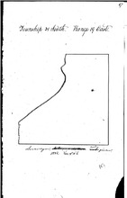
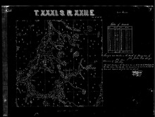
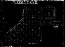
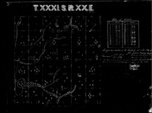
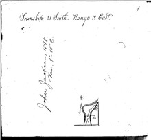
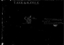
This collection of survey maps, most from 1843-1848, are the initial survey maps by the Territory and State of Florida to enable land sales. This town ship encompasses land centered north and south of today's Apollo Beach area, Riverview (South), Boyette, Balm and Picnic, east to the Polk County line.
Language
eng
Displaying 1 - 7 of 7

1843 Survey Map of Township 31S, Range 19E

hccfl_1694-Thumbnail Image.jpg
Type: Still Image
Member of: Township 31S Survey Maps: Ranges 18E to 22E
Description: This survey was from the initial survey of East Florida lands commissioned when Florida was still a Territory of the US Government. All of Florida was surveyed into Townships (running north and south) and Ranges (running east and west) with all measurements begun with meridians established in Tallahassee, FL. This survey map, completed in 1843, shows the basic outline of lands, south of Bull… more
Full Text: http://rightsstatements.org/vocab/NoC-US/1.0/ …

1847 Survey Map of Township 31S, Range 21E

hccfl_1709-Thumbnail Image.jpg
Type: Still Image
Year: 1847, 1847
Member of: Township 31S Survey Maps: Ranges 18E to 22E
Description: This section of land encompasses lands in the east central area of Township 31 in areas containing today's Boyette and Balm communities. Note the marked Indian Trail running from section 6 in the Upper NW section to the south central section 33. more
Full Text: http://rightsstatements.org/vocab/NoC-US/1.0/ …

1848 Survey of Township 31S, Range 22E

hccfl_1708-Thumbnail Image.jpg
Type: Still Image
Year: 1848, 1848, 1848, 1848
Member of: Township 31S Survey Maps: Ranges 18E to 22E
Description: This land is the eastern most section of Township 31 in today's Hillsborough County. Today, the small area called "Picnic" is on west central edge of the tract, in section 19. The survey examines lands east of that area to the county line with Polk County. This survey was completed in 1848 by John Jackson, one of Tampa's founding fathers, and surveyor of Tampa's town in… more
Full Text: http://rightsstatements.org/vocab/NoC-US/1.0/ …

1847 Survey Map of Township 31S, Range 19E

hccfl_1704-Thumbnail Image.jpg
Type: Still Image
Year: 1847, 1847
Member of: Township 31S Survey Maps: Ranges 18E to 22E
Description: This 1847 Survey map delineates land that lies on Tampa Bay, north of Ruskin, in roughly the area where today's Apollo Beach is located. Note the marking of salt marshes on the western edge of the map, and the rather extensive forestation (indicated by tree marks) inland. This can give an idea on the character of the land before many settlers arrived. more
Full Text: http://rightsstatements.org/vocab/NoC-US/1.0/ …

1847 Survey Map of Township 31S, Range 20E

hccfl_1710-Thumbnail Image.jpg
Type: Still Image
Year: 1847, 1847, 1847, 1847
Member of: Township 31S Survey Maps: Ranges 18E to 22E
Description: These lands were surveyed by Tampa surveyor, John Jackson in 1847 and include lands east of Apollo Beach, and today's US 41, in an area roughly bounded by Big Bend Road, US 41, 19th Street (Ruskin) and US 301. Note the trail marked as "Trail from Manatee to Tampa" running in a rougly NE direction from Section 30 to Section 4. Also note that there is some land marked as "… more
Full Text: http://rightsstatements.org/vocab/NoC-US/1.0/ …

1848 Survey of Township 31S, Range 18E

hccfl_1711-Thumbnail Image.jpg
Type: Still Image
Year: 1948, 1948
Member of: Township 31S Survey Maps: Ranges 18E to 22E
Description: Survey of Mangrove Point at the SE Corner of the Township. Note the phrase "mangrove, impossible, inundated." This is a likely reference to John Jackson's inability to survey further due to the terrain. more
Full Text: http://rightsstatements.org/vocab/NoC-US/1.0/ …

1847 Survey Map of Township 31S, Range 18E

hccfl_1712-Thumbnail Image.jpg
Type: Still Image
Year: 1847, 1847
Member of: Township 31S Survey Maps: Ranges 18E to 22E
Description: Survey by John Jackson of Mangrove Point. Note only land mass is in the SE 1/4 of Section 36, where about half the land shows trees. The rest is either marsh or inundated, per Jackson.
Full Text: http://rightsstatements.org/vocab/NoC-US/1.0/ …
Displaying 1 - 7 of 7

Results per page

  • 15
  • 60
  • 120
  •  List
  •  Grid

Search within Collection

Resource Type

  • (-) Still Image (7)

Creators and Contributors

Publisher

Physical Form

Subject

Subject (name)

Temporal Subject

Year

  • 1847 (4)
  • 1848 (1)
  • 1948 (1)
RSS feed

  This service is a partnership between Florida Virtual Campus,  Library Services and  
Hillsborough Community College. Privacy Statement. All Rights Reserved.
At present, our website is still a work in progress as we continue the archival process of thousands of items.  Our artifact display and research area is currently located inside the Learning Resource Center at the SouthShore Campus and has the same hours as the library.