
Apollo Beach Photo Collection
Displaying 1 - 6 of 6
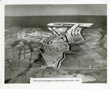
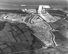
Aerial View October 1960
Type: Still Image
Year: 1960, 1960
Member of: Apollo Beach Photo Collection
Description: Aerial View of Apollo Beach taken in October 1960. Note the expanded dredging operation on the bay side that doubled the sized of the bay portion of the developement.
Full Text: http://rightsstatements.org/vocab/NKC/1.0/ …
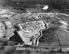
Aerial View of Apollo Beach - 1957
Type: Still Image
Year: 1957, 1957
Member of: Apollo Beach Photo Collection
Description: Aerial View of Apollo Beach from 1957. This photo shows Apollo Beach in its earliest stages of development. In looking at this photo, the veiwer is looking west towards Tampa Bay. US 41 is the North South road at the bottom of the photo. Miller Mac Road (is at the southern end of the developed land and the Flamingo Canal bounds the north. Note the farmland to the south of the development,… more
Full Text: http://rightsstatements.org/vocab/NKC/1.0/ …
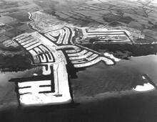
Looking East: 1960
Type: Still Image
Year: 1960, 1960
Member of: Apollo Beach Photo Collection
Publisher: Burgert Brothers
Description: This is the same area as in the Looking West: 1960 picture but from the opposite view. Clearly evidence of the dredge and fill technique being used to create AB. Compare this photo with the 1957 photo to show the addition of the dredged land, creating finger canals.
Full Text: Burgert Brothers … http://rightsstatements.org/vocab/NoC-NC/1.0/ …
Apollo Beach Sign
Type: Still Image
Member of: Apollo Beach Photo Collection
Full Text: http://rightsstatements.org/vocab/NKC/1.0/ …
Looking West: 1960
Type: Still Image
Year: 1960, 1960
Member of: Apollo Beach Photo Collection
Publisher: Burgert Brothers
Description: Looking West at very early Apollo Beach development. At the left side of the developed land is today's Miller Mac Road. On the right, is the Flamingo Canal. US 41 is at the bottom of the page. Note the early sales of lots in the first phases of the property, in what is known as the "F" Street section as most streets begin with the letter "F." Also note the early… more
Full Text: Burgert Brothers … http://rightsstatements.org/vocab/NoC-OKLR/1.0/ …
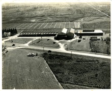
Ruskin Vegetable Cooperative US 541
Type: Still Image
Member of: Apollo Beach Photo Collection
Description: This aerial photo is of the Ruskin Vegetable Cooperative on US541 (now us 41) looking east. On the extreme left is the small white structure that housed the cooperative headquarters. That building survives intact in 2022, and is now the retail facility *MUV" for the marijuana grow facility which replaced the structure in the photo around 2019. The photo looks to be c 1940 based on the… more
Full Text: http://rightsstatements.org/vocab/NKC/1.0/ …