Home
HILLSBOROUGH COMMUNITY COLLEGE DIGITAL LIBRARY
User account menu
  • Log in

Breadcrumb

  1. Home

Township 32S Survey Maps: Ranges 17E to 22E

Description
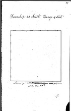
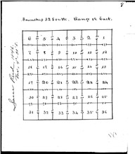
This collection of survey maps, most from 1843-1848, are the initial survey maps by the Territory and State of Florida to enable land sales. This town ship encompasses land including the entire Little Manatee River basin, Ruskin, Sun City, Sun City Center, Wimauma and Fort Lonesome then east to the Polk County line.
Language
eng
Displaying 1 - 4 of 4

1843 Survey Map of Township 32S, Range 19E

hccfl_1695-Thumbnail Image.jpg
Type: Still Image
Year: 1843, 1843
Member of: Township 32S Survey Maps: Ranges 17E to 22E
Description: This 1843 survey, conducted when Florida was still a territory of the United States, indicates the basic delineation of Township 32S, Range 19E, lands including the eastern parts of today's Ruskin and much of Sun City Center, south to today's Hillsborough County line. This initial survey was conducted using a beginning point in Tallahassee with Townships running North and South from… more
Full Text: http://rightsstatements.org/vocab/NoC-US/1.0/ …

1847 Survey Map of Township 32S, Range 17E

hccfl_1707-Thumbnail Image.jpg
Type: Still Image
Year: 1847, 1847, 1847, 1847
Member of: Township 32S Survey Maps: Ranges 17E to 22E
Description: This is a small section of land at the extreme SW corner of Hillsborough County. It sits at the county line with Manatee County, at this time, and has likely been changed through dredging.
Full Text: http://rightsstatements.org/vocab/NoC-US/1.0/ …

1846 Sectional Survey of Township 32S, Range 19E

hccfl_1723-Thumbnail Image.jpg
Type: Still Image
Year: 1846, 1846
Member of: Township 32S Survey Maps: Ranges 17E to 22E
Description: Sectional Survey of T32S, R19E, which includes the eastern part of Ruskin to Sun City Center and then south to the Manatee County line. This sectional survey was requested by the Internal Improvement Fund for the STate of Florida preparatory to selling lands to raise money for the new state of Florida.
Full Text: http://rightsstatements.org/vocab/NoC-US/1.0/ …

1847 Survey Map of Township 32S, Range 18E

hccfl_1706-Thumbnail Image.jpg
Type: Still Image
Year: 1847, 1847
Member of: Township 32S Survey Maps: Ranges 17E to 22E
Description: This survey map details land at the mouth of the Little Manatee River and south. Gulf City, Cockroach Bay and barrier islands are shown. Note the extensive salt marshes and extensive tree markings indicating likely heavy forestation of this area south of the Little Manatee River.
Full Text: http://rightsstatements.org/vocab/NoC-US/1.0/ …
Displaying 1 - 4 of 4

Results per page

  • 15
  • 60
  • 120
  •  List
  •  Grid

Search within Collection

Resource Type

  • Still Image (4)

Creators and Contributors

Publisher

Physical Form

Subject

Subject (name)

Temporal Subject

Year

  • 1843 (1)
  • 1846 (1)
  • 1847 (2)
RSS feed

  This service is a partnership between Florida Virtual Campus,  Library Services and  
Hillsborough Community College. Privacy Statement. All Rights Reserved.
At present, our website is still a work in progress as we continue the archival process of thousands of items.  Our artifact display and research area is currently located inside the Learning Resource Center at the SouthShore Campus and has the same hours as the library.